GEOSPATIAL DATA / Maps & Charts
Global Geography Library
Easy access to a vast collection of atlases, maps, charts, and related resources. Or build your own online collection with GGL+.
Extensive Collections on a Searchable Interface
Global Geography Library (GGL) is a comprehensive platform designed to address the challenges of storing and accessing large format materials such as atlases or charts, or large physical collections like national mapping series. GGL simplifies access to such materials by providing an easy to use, searchable platform for discovery and analysis that also enables seamless search and integration with other technologies. The platform can also be utilized for custom projects and collections via East View’s GGL+ program.
Powerful Insights With Global Geography Library
Collections within Global Geography Library are organized into several different families, including:
Why Choose GGL?
- Save Time, Effort and Shelf Space: Extensive collections, aggregated for easy access, all in one place.
- Cost-Effective: High-quality content at a fraction of the cost, without the need for in-house physical storage or digital management.
- Support Preservation Efforts: Preserve and expand access to fragile and/or rare materials.
- Flexible Purchasing: Subscription or one-time purchase options to fit your needs.
- Digital Access: 24/7 access for unlimited simultaneous users.
GGL Features
- Aggregated Collections: Access a diverse range of maps, charts, explanatory notes, and related materials – both in copyright and non-copyright – all on one platform.
- User-Friendly Interface: The intuitive interface allows users to navigate the library, access resources, and search with ease.
- Precise Metadata and Usage Statistics: Detailed item-level metadata and citation generators make it easy to find and cite materials, while usage statistics and MARC records are available upon request.
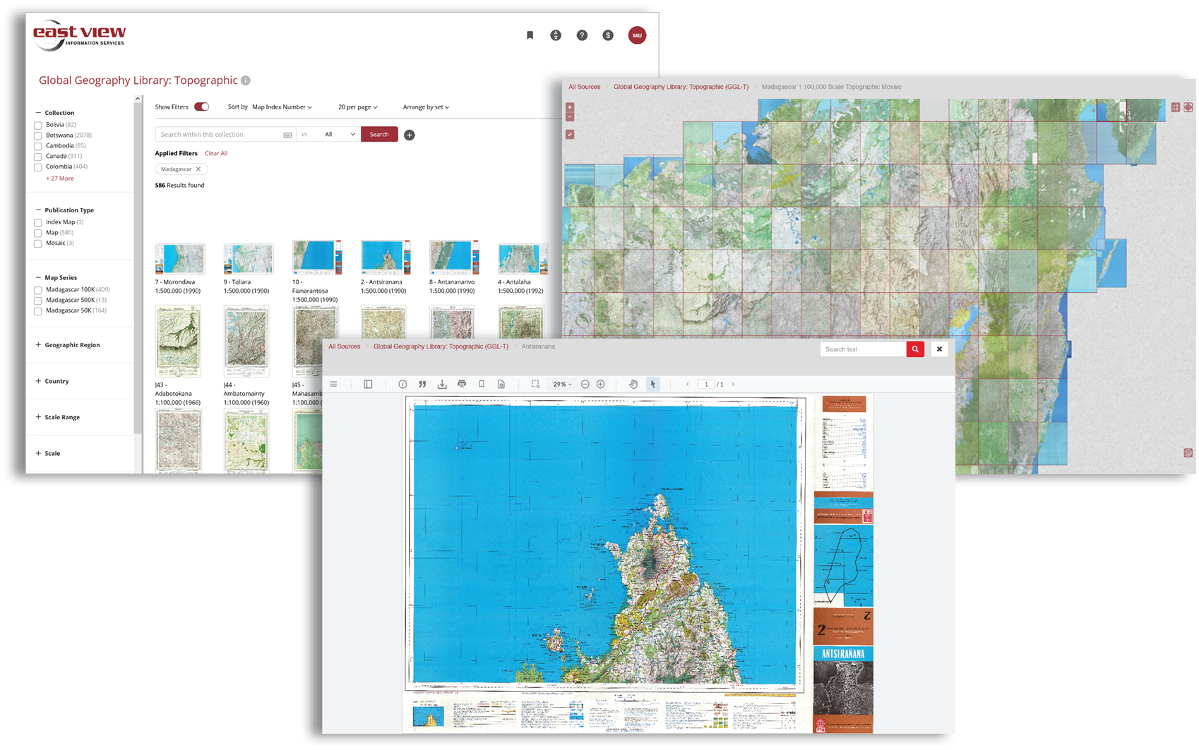
- Powerful Searching: Quickly locate your desired content with an intuitive search system that scans everything, down to the text within individual map interiors (where available), allowing for fast identification of places and features.
- Cross-Referencing and Related Resources: In addition to maps, users can access related documents such as reports and studies, creating a comprehensive knowledge base.
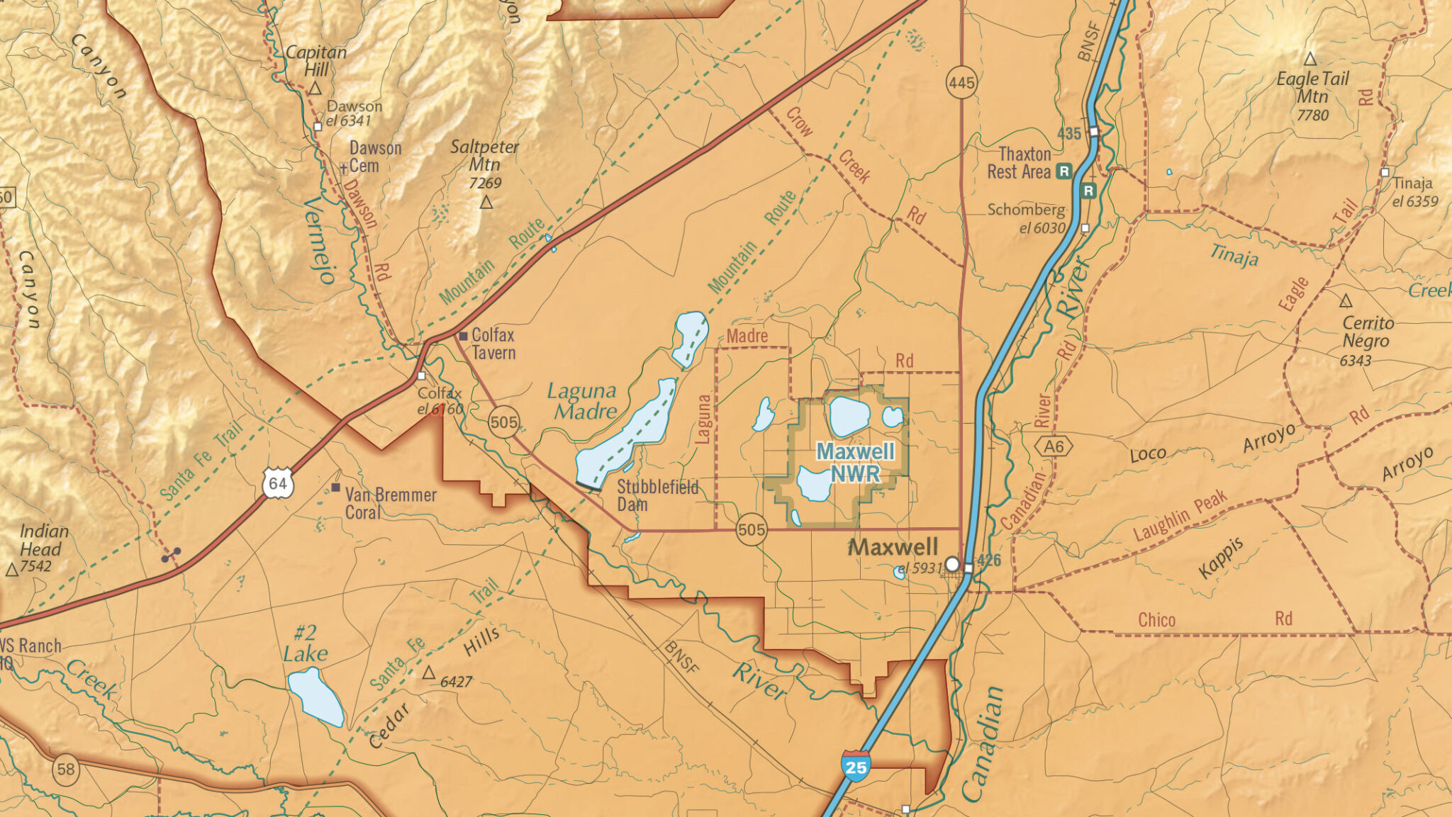
- Dynamic Index Maps for Spatial Discovery: Discover individual maps interactively with dynamic index maps that offer geospatial context.
More than Maps
On top of searchable content, users will find accompanying index maps useful for spatial discovery, alongside a variety of related documents.
Search, Share and Integrate
GGL was designed with usability in mind. Intuitive search, permanent URLs for each item, and seamless mosaics mean faster discovery and easy sharing.
- High-res Viewing: View high-res maps and charts directly on the platform, leveraging IIIF technology for zoom and detail.
- Permanent URLs: Each map has a unique, permanent URL, allowing users to reference and share specific resources.
- Seamless Map Mosaics: Users can view a seamless mosaic of maps, providing a complete picture of an area while maintaining proper spatial relationships among the maps.
- GIS Integration: Seamlessly integrate geomosaics into popular GIS systems via WMTS for enhanced spatial analysis.
GGL Collections
Contact Us for more information or to request a trial or sample data.
Please note that GGL is continually growing with new collections constantly in development.
If there is a country or series you are interested in that does not appear below please Contact Us to discuss availability.
Aeronautical
| Collection Name | Item Count | Published | Index Map/Title List |
|---|---|---|---|
| Global Aeronautical 5M (GNC – NGA) | 30 | 1981-1999 | index map / title list |
| Global Aeronautical 2M (JNC – NGA) | 120 | 1971-1999 | index map / title list |
| Global Aeronautical 1M (ONC – NGA) | 216 | 1969-2005 | index map / title list |
| South Africa Aeronautical 500K (CDSM) | 34 | 1995-2015 | index map / title list |
| USA Aeronautical 1M (WAC – FAA) | 20 | 2015 | index map / title list |
Atlases
| Collection Name | Item Count | Published | Title List |
|---|---|---|---|
| The Times Comprehensive Atlas of the World | 45 | 1895-2023 | title list |
Earth Sciences
| Collection Name | Item Count | Published | Index Map/Title List |
|---|---|---|---|
| Afghanistan Geological 250K (USGS) | 32 | 2005 | index map / title list |
| Brazil Geological 100K | 394 | 1998-2024 | index map / title list |
| Canada Geological 50K – Nova Scotia (NS Geoscience & Mines) | 25 | 2017 | index map / title list |
| Greece Earth Sciences (IGME / HSGME) | 347 | 1951-2001 | title list |
| Greece Geological 50K | 326 | 1956-2015 | index map / title list |
| Israel Geological 250K | 2 | 2021 | index map / title list |
| Mozambique Geological 250K (includes 4 explanatory notes) | 78 | 2006-2007 | index map / title list |
| Mozambique Geological 250K (GIS Vector Data) | 101 | 2006-2007 | index map |
| Russia Geological 1000K (3rd Gen) | 1,342 | 2006-2024 | |
| Wilderness Mineral Potential (USA; Vol. 1 & 2; maps, vector data & reports) | 978 | 1984 | title list |
| Zambia Geological 100K (includes 98 explanatory notes) | 254 | 1960s-2016 | index map / title list |
Maritime
| Collection Name | Item Count | Published | Index Map/Title List |
|---|---|---|---|
| Cuba Nautical Charts (All Scales) | 226 | 2010s-2024 | index map / title list |
| Israel Nautical Charts (All Scales) | 12 | 2009-2023 | index map / title list |
| NOAA Nautical Charts (Final Editions) | 1,023 | 2000-2024 | title list |
| Norway Nautical Charts (All Scales) | 238 | 2007-2016 | title list |
Terrain Analysis Reports
Collections include 1:200,000 topographic maps, reports (in Russian and English), and soil diagrams (learn more).
| Collection Name | Item Count | Published | Title List |
|---|---|---|---|
| Afghanistan Terrain Analysis 200K | 512 | 1960s-1990s | index map / title list |
| China Terrain Analysis 200K | 6,409 | 1960s-1990s | index map / title list |
| Israel Terrain Analysis 200K | 48 | 1960s-1990s | index map / title list |
| Jordan Terrain Analysis 200K | 104 | 1960s-1990s | index map / title list |
| North Korea Terrain Analysis 200K | 141 | 1960s-1990s | index map / title list |
| Syria & Lebanon Terrain Analysis 200K | 188 | 1960s-1990s | index map / title list |
| Ukraine Terrain Analysis 200K | 617 | 1960s-1990s | index map / title list |
Thematic, Reference, Commercial, Educational
| Collection Name | Item Count | Published | Title List |
|---|---|---|---|
| Collins Bartholomew World Maps | 150 | 1858-2024 | title list |
| freytag & berndt – Africa Books | 23 | 2013-2024 | |
| freytag & berndt – Africa Maps | 27 | 2009-2023 | |
| freytag & berndt – Americas Books | 32 | 2013-2024 | |
| freytag & berndt – Americas Maps | 46 | 2009-2025 | |
| freytag & berndt – Asia Books | 58 | 2011-2024 | |
| freytag & berndt – Asia Maps | 67 | 2008-2025 | |
| freytag & berndt – Austria Books | 14 | 2007-2023 | |
| freytag & berndt – Austria Maps | 101 | 2007-2025 | |
| freytag & berndt – Europe Atlases | 19 | 2017-2025 | |
| freytag & berndt – Europe Books | 124 | 2011-2024 | |
| freytag & berndt – Europe Maps | 329 | 2006-2025 | |
| freytag & berndt – Germany and Austria Bicycling | 125 | 2005-2025 | |
| freytag & berndt – Germany and Austria Hiking | 403 | 2004-2025 | |
| freytag & berndt – Germany Books | 8 | 2022 | |
| freytag & berndt – Germany Maps | 212 | 2008-2025 | |
| freytag & berndt – Oceania Maps and Books | 15 | 2008-2025 | |
| freytag & berndt – World and Continents | 43 | 2009-2025 | |
| Gitashenasi Maps (Iran) | 500+ | 1975-2025 | title list |
| Survey of Israel Thematic Maps | 15 | 2014-2023 | title list |
| Tom Harrison Maps | 87 | 2013-2024 | title list |
| Ukraine Cartographic Group Maps | 92 | 2008-2024 | title list |
| Venezuela State Land Use | 23 | 2015 | index map / title list |
| Venezuela State Natural Resources | 23 | 2015 | index map / title list |
| Venezuela State Physical Regions | 43 | 2009-2016 | index map / title list |
| Venezuela State Political Maps | 23 | 2015 | index map / title list |
Topographic
| Collection Name | Item Count | Published | Index Map/Title List |
|---|---|---|---|
| Bolivia Topographic 250K (GIS Vector Data) | 82 | 2010 | title list |
| Colombia Topographic 2K (GIS Vector Data) | 513 | 2003-2018 | index map / title list |
| Colombia Topographic 25K | 4,730 | 1995-2018 | index map / title list |
| Colombia Topographic 25K (GIS Vector Data) | 6,582 | 1995-2018 | index map / title list |
| Colombia Topographic 100K | 716 | 2005-2016 | index map / title list |
| Colombia Topographic 100K (GIS Vector Data) | 599 | 2005-2016 | index map / title list |
| Cuba Topographic 100K (Soviet Military) | 121 | 1976-1977 | index map / title list |
| Czechia Topographic 25K (CUZK) | 717 | 2023 | index map / title list |
| Czechia Topographic 25K (GIS Vector Data) | 717 | 2023 | index map / title list |
| Czechia Topographic 50K (CUZK) | 202 | 2023 | index map / title list |
| Czechia Topographic 50K (GIS Vector Data) | 202 | 2023 | index map / title list |
| Czechia Topographic 100K (CUZK) | 60 | 2023 | index map / title list |
| Czechia Topographic 100K (GIS Vector Data) | 60 | 2023 | index map / title list |
| Czechia Topographic 250K (CUZK) | 12 | 2023 | index map / title list |
| Czechia Topographic 250K (GIS Vector Data) | 12 | 2023 | index map / title list |
| Israel Topographic City Maps | 1,645 | 2023 | title list |
| Israel Topographic 25K (2023-Hebrew) | 97 | 2023 | index map / title list |
| Israel Topographic 25K (2024-English) | 97 | 2024 | index map / title list |
| Israel Topographic 50K (2024-Hebrew) | 28 | 2024 | index map / title list |
| Israel Topographic 50K (2020-English) | 28 | 2020 | index map / title list |
| Israel Topographic 100K (2019-Hebrew) | 22 | 2019 | index map / title list |
| Karta Mira Topographic 2.5M | 262 | 1946-1980 | index map / title list |
| Madagascar Topographic 50K | 162 | 1955-1988 | index map / title list |
| Madagascar Topographic 100K | 452 | 1950-1998 | index map / title list |
| Madagascar Topographic 500K | 11 | 1985-1992 | index map / title list |
| Malawi Topographic 50K | 153 | 1962-1996 | index map / title list |
| Malawi Topographic 50K (GIS Vector Data) | 162 | 2017 | title list |
| Mexico Topographic 20K | 2,360 | 2007-2017 | index map / title list |
| Mexico Topographic 20K (GIS Vector Data) | 2,465 | 2018 | index map / title list |
| Mexico Topographic 50K | 2,294 | 1983-2021 | index map / title list |
| Mexico Topographic 50K (GIS Vector Data) | 2,361 | 2013-2018 | index map / title list |
| Mexico Topographic 250K | 122 | 2017-2020 | index map / title list |
| Mexico Topographic 500K | 9 | 1998-2020 | index map / title list |
| Mongolia Topographic 100K | 1,153 | 1957-1985 | index map / title list |
| Mozambique Topographic 25K | 21 | 1998 | index map / title list |
| Myanmar Topographic 50K (EV Map) | 1,148 | 2014 | index map / title list |
| Panama Topographic 50K (US Military – Series E762) | 167 | 1959-1999 | index map / title list |
| Papua New Guinea Topographic 100K (T601) | 196 | 1975-2001 | index map / title list |
| Romania Topographic 50K (CNC) | 740 | 2019 | index map / title list |
| Romania Topographic 100K (CNC) | 204 | 2019 | index map / title list |
| Samoa Topographic 50K (EV Map) | 16 | 2020 | index map / title list |
| Senegal Topographic 50K | 142 | 1955-1971 | index map / title list |
| Senegal Topographic 200K | 27 | 2005-2008 | index map / title list |
| Tanzania Topographic 50K | 1,250 | 1954-2019 | index map / title list |
| Tanzania Topographic 250K | 64 | 1960-2000 | index map / title list |
| United States Vicinity Maps (USGS) | 80 | 1937-1965 | index map / title list |
| Uzbekistan Topographic 25K | 1,771 | 2023 | index map / title list |
| Uzbekistan Topographic 25K (GIS Vector Data) | 1,738 | 2023 | index map / title list |
| Yemen Topographic 50K | 171 | 1979-1998 | index map / title list |
| Yemen Topographic 100K | 162 | 1978 | index map / title list |
| Yemen Topographic 200K | 64 | 1984 | index map / title list |
| Zambia Topographic 50K | 589 | 1960-1997 | index map / title list |
| Zambia Topographic 100K | 53 | 1960-1997 | index map / title list |
| Zambia Topographic 250K | 59 | 1960-1997 | index map / title list |
Note: GGL is continually growing, with new collections constantly being produced. If there is a country and/or map series you are interested in that does not appear on this list, please contact us to discuss availability and status.
Build Your Own Collections with GGL+
GGL+ is a fully customizable platform option for customers wanting to digitize and platformize their own materials, with the option to add any of East View’s pre-built collections.
GGL+ can accommodate a wide variety of materials and formats, including PDFs, high-resolution IIIF image files, and zip files. While most GGL collections are map focused, customers can host virtually any content, including data, handbooks, and other internal documents.
GGL+ also accommodates multiple access models (IP authentication and/or username/password), with the ability to restrict access to certain materials for different users.
Global Geography Library: Request More Information or Free Trial Access
Free trials provide temporary access to the databases that East View produces or hosts. This allows organizations and their employees to evaluate the content and platform. For large organizations we are able to set up access via a domain-wide, automatically authenticated Internet Protocol (IP) address.
For individuals, we set up trial access only in special cases. We encourage individuals who wish to explore our content and platforms to contact their digital resources manager at your organization. We are better able to serve you through their systems. Please help us work with your organization by filling in the appropriate fields in the form, below.