SOLUTIONS / DATA PRODUCTION
Imagery Processing
Imagery options and applications are constantly advancing. East View Geospatial will help you get the most out of your imagery with a full range of services designed to fit your requirements.
Preparing Your Imagery for Integration and Analysis
As imagery experts, we know the challenges that can come with collecting and utilizing aerial and satellite imagery. Whether creating country-wide seamless mosaics or improving an image’s resolution, we make sure your imagery is delivered as needed.
Personalized Processing
We prepare imagery for many different end users and applications, from imagery analysts and art enthusiasts to integration into software and mission control systems. We crop, compress, mosaic, or transform your image so you get the display and coverage you require. Deliverable in all standard formats along with unique formats such as CIB or MrSID, your imagery will be ready on arrival.
Quality Improvements
Images may not always turn out the way you want, but that doesn’t mean you have to task a new collection. We are capable of many imagery enhancements and techniques, from cloud removal and color balancing to pan sharpening and much more.
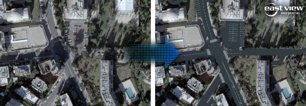
Imagery Without Flaws
Satellite imagery has emerged as one of the most cost-effective and powerful tools for organizations to gain spatial awareness and make data-driven decisions. We take it a step further by removing inconsistency’s like shadows and vehicles ensuring the clearest, most refined imagery possible. Our modified high resolution imagery is perfect for in depth analysis and visual representation without the distractions of every day life.
Imagery Services
- Orthorectification
- Pan-sharpen/color balance/mosaic multiple scenes
- Image clean-up, cloud removal, feathering
- GCP integration
Learn More about Our Imagery Offerings