Discrimination within housing was made illegal under the Civil Rights Act of 1968. However, there are still residual effects from decades of racially biased housing policies in cities all around the United States. Redlining, the federal act of denying mortgages to non-white home buyers, is a well-known discriminatory practice. Another instance of discrimination within housing that is less well known is the implementation of racially restrictive covenants.
A racial covenant (example pictured below) is language that is written into a land deed which prohibits people from owning or living on that property based on race.

Image courtesy of the Mapping Prejudice Project.
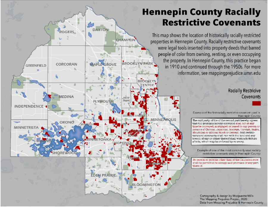
Racial covenants are also unique because they are bound to the land and not the structure(s) on that land. The Mapping Prejudice Project (MP), based at the John R. Borchert Map Library in Minneapolis, MN, has made it their mission to identify these racial covenants & illustrate how racist policy shaped the geography of the Twin Cities through data visualization. Many of these covenants still stand today.
Projects to identify racial covenants have been ongoing for years. Segregated Seattle assembled a database of racial covenants, while Mapping Inequality digitized redlining maps to show how policy decisions can seriously impact neighborhoods. MP created a database of racial covenants in Hennepin County, Minnesota. In 2016, the MP team created the first-ever time-lapse visualization of racial covenants in Minneapolis, allowing people to see exactly where and when this discrimination occurred. The project has since grown to include racial covenants in neighboring Ramsey County, where state capitol St. Paul is located.

The distribution of known racially covenants in Hennepin County, Minnesota. Map courtesy of Marguerite Mills & the Mapping Prejudice Project.
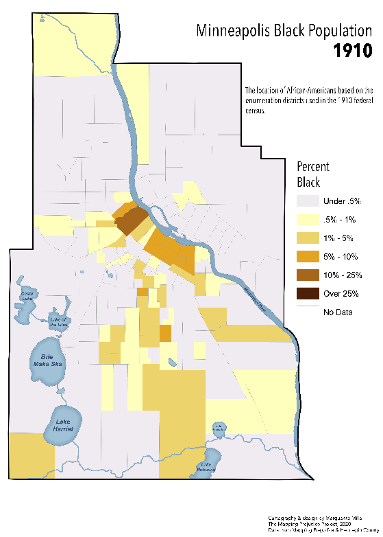
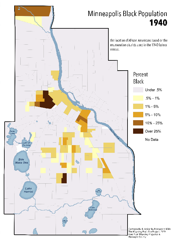
To give some background, in 1910, the city of Minneapolis was relatively integrated, as many northern cities were at the time. There were several families of color in many different areas of the city. By 1940, however, almost all families of color were concentrated into a few neighborhoods in Minneapolis, even though there was no drastic influx of new people/families of color to the greater Twin Cities area. Non-white families were forced to live in these areas due to widespread implementation of racial covenants in land deeds (see images below).
African-American families in Minneapolis in 1910 and 1940. Maps courtesy of Marguerite Mills & the Mapping Prejudice Project.
The way racial covenants work is that the initial person who places the covenant on the property can “reclaim” the property if the covenant should be broken. If a property is bought or leased by a person or family of color after the covenant is placed but the original property owner comes forward, the family of color loses the property and all equity accumulated. The property then reverts to the initial owner (or an heir/descendant of the original owner if they are no longer alive). Legally, covenants are extremely difficult to undo, but Minnesota Governor Tim Walz signed a bill into law in June of 2019 that allows homeowners to disavow racial covenants associated with their property. The Mapping Prejudice Project has inspired many residents of Hennepin & Ramsey counties to investigate if their property has a racial covenant & disavow the language if a covenant is identified.
Currently, over 24,000 racially restrictive covenants have been identified & mapped within Hennepin County alone. There are still more within Hennepin County to be identified, and the Mapping Prejudice Project has begun to identify racial covenants in Ramsey County as well. You can help the MPP team identify covenants virtually! After completing the training video, you’ll be able to identify and report racially restrictive housing covenants in digitized deeds. Find out more about getting involved here.
Though racial covenants have been illegal for over 50 years, they continue to impact people through the ways they shaped the geographies of cities. The research done by the Mapping Prejudice Project team has clearly illustrated that current inequalities stem from past racist policies and blatant discrimination. Through awareness & education, The Mapping Prejudice Project strives to create a more just and equitable future.


